
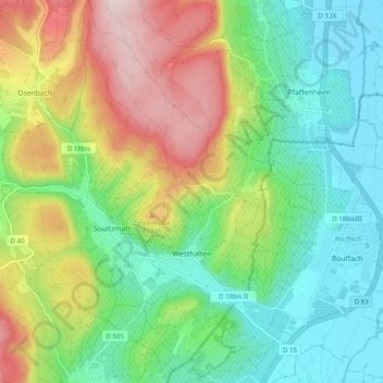
Westhalten topographic map
Interactive map
Click on the map to display elevation.
About this map
Name: Westhalten topographic map, elevation, terrain.
Average elevation: 1,102 ft
Minimum elevation: 643 ft
Maximum elevation: 1,942 ft
Le village viticole est niché entre les collines du Bollenberg, du Strangenberg et du Zinnkoepflé (qui a donné son nom au grand cru produit notamment à Westhalten) dans une des zones les plus sèches de France. La limite supérieure de la culture de la vigne atteint l'altitude de 460 mètres.
Other topographic maps
Click on a map to view its topography, its elevation and its terrain.
Bantzenheim
France > Grand Est > Haut-Rhin
Bantzenheim, Mulhouse, Haut-Rhin, Grand Est, France métropolitaine, 68490, France
Average elevation: 719 ft
Fessenheim
France > Grand Est > Haut-Rhin
Fessenheim, Colmar-Ribeauvillé, Haut-Rhin, Grand Est, France métropolitaine, 68740, France
Average elevation: 682 ft
Valdieu-Lutran
France > Grand Est > Haut-Rhin
Valdieu-Lutran, Altkirch, Haut-Rhin, Grand Est, France métropolitaine, 68210, France
Average elevation: 1,155 ft
Zillisheim
France > Grand Est > Haut-Rhin
Zillisheim, Mulhouse, Haut-Rhin, Grand Est, France métropolitaine, 68720, France
Average elevation: 997 ft
Lautenbachzell
France > Grand Est > Haut-Rhin
Lautenbachzell, Thann-Guebwiller, Haut-Rhin, Grand Est, France métropolitaine, 68610, France
Average elevation: 2,992 ft
La Trinque
France > Grand Est > Haut-Rhin > Labaroche
La Trinque, Labaroche, Colmar-Ribeauvillé, Haut-Rhin, Grand Est, France métropolitaine, 68910, France
Average elevation: 2,402 ft
Hagenthal-le-Bas
France > Grand Est > Haut-Rhin
Hagenthal-le-Bas, Mulhouse, Haut-Rhin, Grand Est, France métropolitaine, 68220, France
Average elevation: 1,296 ft
Guebwiller
France > Grand Est > Haut-Rhin
Guebwiller, Thann-Guebwiller, Haut-Rhin, Grand Est, France métropolitaine, 68500, France
Average elevation: 1,243 ft
Masevaux-Niederbruck
France > Grand Est > Haut-Rhin > Masevaux-Niederbruck
Masevaux-Niederbruck, Thann-Guebwiller, Haut-Rhin, Grand Est, France métropolitaine, 68290, France
Average elevation: 1,893 ft
Ottmarsheim
France > Grand Est > Haut-Rhin
Ottmarsheim, Mulhouse, Haut-Rhin, Grand Est, France métropolitaine, 68490, France
Average elevation: 735 ft
Wittelsheim
France > Grand Est > Haut-Rhin
Wittelsheim, Mulhouse, Haut-Rhin, Grand Est, France métropolitaine, 68310, France
Average elevation: 860 ft
Schlierbach
France > Grand Est > Haut-Rhin
Schlierbach, Mulhouse, Haut-Rhin, Grand Est, France métropolitaine, 68440, France
Average elevation: 906 ft