
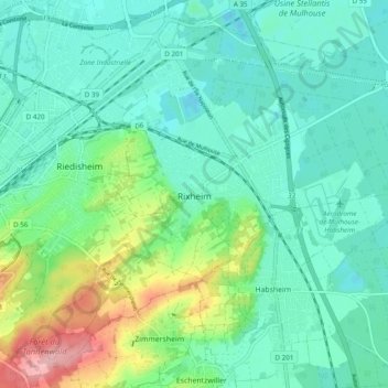
Rixheim topographic map
Interactive map
Click on the map to display elevation.
About this map
Name: Rixheim topographic map, elevation, terrain.
Average elevation: 840 ft
Minimum elevation: 725 ft
Maximum elevation: 1,204 ft
À 5 kilomètres de la ville-centre de Mulhouse, à la croisée des routes de Strasbourg et Mulhouse intra-muros à Bâle (A35-A36 à Sausheim) et de Habsheim à Ottmarsheim (anciennes voies romaines), la commune de Rixheim est située dans une anse du fossé rhénan aux confins de la forêt domaniale de la Hardt, des collines sundgauviennes et de la plaine alluviale de l’Ill. Les altitudes varient entre 365 mètres (Zürenwald) et 232 mètres (Pont du Bouc).
Other topographic maps
Click on a map to view its topography, its elevation and its terrain.
Westhalten
France > Grand Est > Haut-Rhin
Westhalten, Thann-Guebwiller, Haut-Rhin, Grand Est, France métropolitaine, 68250, France
Average elevation: 1,102 ft
Bantzenheim
France > Grand Est > Haut-Rhin
Bantzenheim, Mulhouse, Haut-Rhin, Grand Est, France métropolitaine, 68490, France
Average elevation: 719 ft
Fessenheim
France > Grand Est > Haut-Rhin
Fessenheim, Colmar-Ribeauvillé, Haut-Rhin, Grand Est, France métropolitaine, 68740, France
Average elevation: 682 ft
Valdieu-Lutran
France > Grand Est > Haut-Rhin
Valdieu-Lutran, Altkirch, Haut-Rhin, Grand Est, France métropolitaine, 68210, France
Average elevation: 1,155 ft
Zillisheim
France > Grand Est > Haut-Rhin
Zillisheim, Mulhouse, Haut-Rhin, Grand Est, France métropolitaine, 68720, France
Average elevation: 997 ft
Lautenbachzell
France > Grand Est > Haut-Rhin
Lautenbachzell, Thann-Guebwiller, Haut-Rhin, Grand Est, France métropolitaine, 68610, France
Average elevation: 2,992 ft
La Trinque
France > Grand Est > Haut-Rhin > Labaroche
La Trinque, Labaroche, Colmar-Ribeauvillé, Haut-Rhin, Grand Est, France métropolitaine, 68910, France
Average elevation: 2,402 ft
Hagenthal-le-Bas
France > Grand Est > Haut-Rhin
Hagenthal-le-Bas, Mulhouse, Haut-Rhin, Grand Est, France métropolitaine, 68220, France
Average elevation: 1,296 ft
Guebwiller
France > Grand Est > Haut-Rhin
Guebwiller, Thann-Guebwiller, Haut-Rhin, Grand Est, France métropolitaine, 68500, France
Average elevation: 1,243 ft
Masevaux-Niederbruck
France > Grand Est > Haut-Rhin > Masevaux-Niederbruck
Masevaux-Niederbruck, Thann-Guebwiller, Haut-Rhin, Grand Est, France métropolitaine, 68290, France
Average elevation: 1,893 ft
Wittelsheim
France > Grand Est > Haut-Rhin
Wittelsheim, Mulhouse, Haut-Rhin, Grand Est, France métropolitaine, 68310, France
Average elevation: 860 ft
Schlierbach
France > Grand Est > Haut-Rhin
Schlierbach, Mulhouse, Haut-Rhin, Grand Est, France métropolitaine, 68440, France
Average elevation: 906 ft
Ottmarsheim
France > Grand Est > Haut-Rhin
Ottmarsheim, Mulhouse, Haut-Rhin, Grand Est, France métropolitaine, 68490, France
Average elevation: 735 ft