
Biel-Benken topographic map
Interactive map
Click on the map to display elevation.
About this map
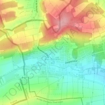
Name: Biel-Benken topographic map, elevation, terrain.
Location: Biel-Benken, Bezirk Arlesheim, Bâle-Campagne, 4105, Suisse (47.49678 7.49787 47.52125 7.53670)
Average elevation: 1,178 ft
Minimum elevation: 997 ft
Maximum elevation: 1,411 ft
Other topographic maps
Click on a map to view its topography, its elevation and its terrain.
Muttenz
Suisse > Bâle-Campagne > Bezirk Arlesheim > Muttenz
Muttenz, Bezirk Arlesheim, Bâle-Campagne, 4132, Suisse
Average elevation: 1,119 ft