Geolocate

Sellano topographic map

Click on the map to display elevation.

About this map

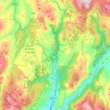
Name: Sellano topographic map, elevation, terrain.

Location: Sellano, Perugia, Umbria, 06030, Italy (42.84881 12.80312 42.93604 12.97679)

Average elevation: 2,779 ft

Minimum elevation: 1,247 ft

Maximum elevation: 4,875 ft

Gear up for your next adventure:

📻Weather Alert Radios - Stay informed of storm risks while off-the-grid
🧭Compass with Lanyard - Easy‑carry compass for navigation
🚪Portable Camp Chair - Foldable chair for comfort at camp
🪶Camp Gear Gift Set - Perfect gift bundle for outdoor fans
📌Outdoor GPS Map App - Apps and devices for digital topographic navigation

As an Amazon Associate, this site earns from qualifying purchases at no extra cost to you.