
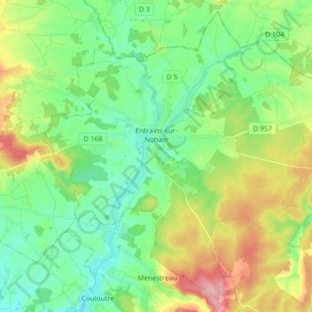
Entrains-sur-Nohain topographic map
Interactive map
Click on the map to display elevation.
About this map
Name: Entrains-sur-Nohain topographic map, elevation, terrain.
Average elevation: 801 ft
Minimum elevation: 653 ft
Maximum elevation: 1,099 ft
Other topographic maps
Click on a map to view its topography, its elevation and its terrain.
Nevers
France > Bourgogne-Franche-Comté > Nièvre
Nevers, Nièvre, Bourgogne-Franche-Comté, France métropolitaine, 58000, France
Average elevation: 614 ft
Imphy
France > Bourgogne-Franche-Comté > Nièvre
Imphy, Nevers, Nièvre, Bourgogne-Franche-Comté, France métropolitaine, 58160, France
Average elevation: 659 ft
Dampierre-sous-Bouhy
France > Bourgogne-Franche-Comté > Nièvre
Dampierre-sous-Bouhy, Cosne-Cours-sur-Loire, Nièvre, Bourgogne-Franche-Comté, France métropolitaine, 58310, France
Average elevation: 856 ft