
疊石塘山 topographic map
Interactive map
Click on the map to display elevation.
About this map
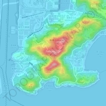
Name: 疊石塘山 topographic map, elevation, terrain.
Location: 疊石塘山, 路環, 澳門, 999078, 中国 (22.12060 113.56125 22.12070 113.56135)
Average elevation: 89 ft
Minimum elevation: -16 ft
Maximum elevation: 505 ft
疊石塘山(葡萄牙語:Alto de Coloane),又名路環塔石塘山,位於澳門路環,海拔170.59米,如計算混凝土立面總高度為172.41米,為澳門最高點。
Other topographic maps
Click on a map to view its topography, its elevation and its terrain.
路環山頂公園 Jardim de Alto de Coloane
路環山頂公園 Jardim de Alto de Coloane, 石排灣, 路環, 澳門, 中国
Average elevation: 98 ft