Geolocate

Haggate topographic map

Click on the map to display elevation.

About this map

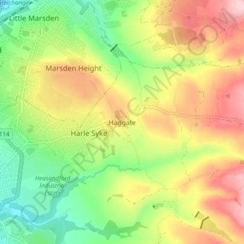
Name: Haggate topographic map, elevation, terrain.

Location: Haggate, Burnley, Lancashire, England, BB10 3QH, United Kingdom (53.79341 -2.21472 53.83341 -2.17472)

Average elevation: 722 ft

Minimum elevation: 400 ft

Maximum elevation: 1,099 ft

Other topographic maps

Click on a map to view its topography, its elevation and its terrain.

Briercliffe

United Kingdom > England > Lancashire > Burnley

Average elevation: 922 ft

Habergham Eaves

United Kingdom > England > Lancashire > Burnley

Average elevation: 863 ft

Gear up for your next adventure:

🔪Outdoor Multitools - Essential survival tools for gear repair and field use
🔋Solar Power Banks - Keep your GPS and phone charged in remote wilderness areas
🥘Titanium Cookware - Durable, featherlight pots and pans for backpacking
🪶Survival Guide Book - Expert advice for emergency preparedness
📷Action Camera - Capture your outdoor adventures in HD

As an Amazon Associate, this site earns from qualifying purchases at no extra cost to you.