
Brookwood topographic map
Click on the map to display elevation.
About this map
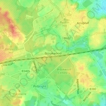
Name: Brookwood topographic map, elevation, terrain.
Location: Brookwood, Woking, Surrey, England, GU24 0HG, United Kingdom (51.28493 -0.65501 51.32493 -0.61501)
Average elevation: 157 ft
Minimum elevation: 89 ft
Maximum elevation: 230 ft
Other topographic maps
Click on a map to view its topography, its elevation and its terrain.
Horsell Common
United Kingdom > England > Surrey > Woking > Horsell > Durnford Farm
Average elevation: 95 ft
Brookwood Country Park
United Kingdom > England > Surrey > Woking > Knaphill
Average elevation: 154 ft