Galveston topographic map
Interactive map
Click on the map to display elevation.
About this map
![Galveston topographic map, elevation, terrain](/pub/maps/relation/b25k/r61tj/thumbnail.jpg)
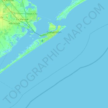
Name: Galveston topographic map, elevation, terrain.
Location: Galveston, Galveston County, Texas, United States (28.99634 -95.12994 29.39940 -94.52566)
Average elevation: 3 ft
Minimum elevation: -23 ft
Maximum elevation: 49 ft
On September 8, 1900, the island was struck by a devastating hurricane. This event holds the record as the United States' deadliest natural disaster. The city was devastated, and an estimated 6,000 to 8,000 people on the island were killed. Following the storm, a 10-mile (16 km) long, 17 foot (5.2 m) high seawall was built to protect the city from floods and hurricane storm surges. A team of engineers including Henry Martyn Robert (Robert's Rules of Order) designed the plan to raise much of the existing city to a sufficient elevation behind a seawall so that confidence in the city could be maintained.
Other topographic maps
Click on a map to view its topography, its elevation and its terrain.
![Galveston Island topographic map, elevation, terrain](/pub/maps/node/mjdn/rbg4w4s/icon.jpg)
Galveston Island
United States > Texas > Galveston County > Galveston
Galveston Island, Galveston, Galveston County, Texas, 77554, United States
Average elevation: 7 ft
![Friendswood topographic map, elevation, terrain](/pub/maps/relation/krr/l68zf3/icon.jpg)
Friendswood
United States > Texas > Galveston County
Friendswood, Galveston County, Texas, 77546, United States
Average elevation: 36 ft
![League City topographic map, elevation, terrain](/pub/maps/relation/dgs8/7n9kl/icon.jpg)
League City
United States > Texas > Galveston County
League City, Galveston County, Texas, 77573, United States
Average elevation: 23 ft
![Dickinson topographic map, elevation, terrain](/pub/maps/relation/6mz4/zzxx5k/icon.jpg)
Dickinson
United States > Texas > Galveston County
Dickinson, Galveston County, Texas, 77539, United States
Average elevation: 20 ft
![San Leon topographic map, elevation, terrain](/pub/maps/node/31rr/n4c3k3q/icon.jpg)
San Leon
United States > Texas > Galveston County
San Leon, Galveston County, Texas, 77395, United States
Average elevation: 3 ft
![Gilchrist topographic map, elevation, terrain](/pub/maps/node/m1mt/7wc2d18/icon.jpg)
Gilchrist
United States > Texas > Galveston County
Gilchrist, Galveston County, Texas, 77617, United States
Average elevation: 3 ft
![La Marque topographic map, elevation, terrain](/pub/maps/relation/lhmt/bb66tf/icon.jpg)
La Marque
United States > Texas > Galveston County
La Marque, Galveston County, Texas, 77568, United States
Average elevation: 13 ft
![Tiki Island topographic map, elevation, terrain](/pub/maps/relation/9fb3/dd4mtp/icon.jpg)
Tiki Island
United States > Texas > Galveston County
Tiki Island, Galveston County, Texas, United States
Average elevation: 0 ft
![Galveston topographic map, elevation, terrain](/pub/maps/node/zztj/nw4hw51/icon.jpg)
Galveston
United States > Texas > Galveston County > Galveston
Galveston, Galveston County, Texas, 77553, United States
Average elevation: 3 ft
![Clifton Beach topographic map, elevation, terrain](/pub/maps/node/x4s8/tm29pcz/icon.jpg)
Clifton Beach
United States > Texas > Galveston County > Bacliff
Clifton Beach, Bacliff, Galveston County, Texas, 77518, United States
Average elevation: 10 ft
![Bacliff topographic map, elevation, terrain](/pub/maps/node/kxf3/x5w6qkl/icon.jpg)
Bacliff
United States > Texas > Galveston County
Bacliff, Galveston County, Texas, 77518, United States
Average elevation: 13 ft
![Texas City topographic map, elevation, terrain](/pub/maps/relation/7s9m/66m8nh/icon.jpg)
Texas City
United States > Texas > Galveston County
Texas City, Galveston County, Texas, United States
Average elevation: 7 ft
![Bolivar Peninsula topographic map, elevation, terrain](/pub/maps/node/lvz4/xbsmkkl/icon.jpg)
Bolivar Peninsula
United States > Texas > Galveston County
Bolivar Peninsula, Galveston County, Texas, United States
Average elevation: 3 ft
![Crystal Beach topographic map, elevation, terrain](/pub/maps/node/brr/9g84w4s/icon.jpg)
Crystal Beach
United States > Texas > Galveston County
Crystal Beach, Galveston County, Texas, 77650, United States
Average elevation: 3 ft
![Bayou Vista topographic map, elevation, terrain](/pub/maps/relation/q95k/33nv51/icon.jpg)
Bayou Vista
United States > Texas > Galveston County
Bayou Vista, Galveston County, Texas, United States
Average elevation: 7 ft
![Texas City topographic map, elevation, terrain](/pub/maps/node/lxgt/n4tll3q/icon.jpg)
Texas City
United States > Texas > Galveston County > Texas City > Texas City
Texas City, Galveston County, Texas, 77590, United States
Average elevation: 10 ft
![Hitchcock topographic map, elevation, terrain](/pub/maps/node/4qtp/9bw7zzs/icon.jpg)
Hitchcock
United States > Texas > Galveston County > Hitchcock > Hitchcock
Hitchcock, Galveston County, Texas, 77563, United States
Average elevation: 16 ft
![Hitchcock topographic map, elevation, terrain](/pub/maps/relation/z9nx/sxgcnh/icon.jpg)
Hitchcock
United States > Texas > Galveston County
Hitchcock, Galveston County, Texas, 77563, United States
Average elevation: 10 ft
![Campeche Cove topographic map, elevation, terrain](/pub/maps/node/xq3l/3q36pt6/icon.jpg)
Campeche Cove
United States > Texas > Galveston County > Galveston > Campeche Cove
Campeche Cove, Galveston, Galveston County, Texas, 77552, United States
Average elevation: 7 ft
![La Marque topographic map, elevation, terrain](/pub/maps/node/6pgp/bz5gxt6/icon.jpg)
La Marque
United States > Texas > Galveston County > La Marque > La Marque
La Marque, Galveston County, Texas, 77568, United States
Average elevation: 16 ft
![Kemah topographic map, elevation, terrain](/pub/maps/relation/rzs/kwd1t6/icon.jpg)
Kemah
United States > Texas > Galveston County
Kemah, Galveston County, Texas, United States
Average elevation: 16 ft
![Santa Fe topographic map, elevation, terrain](/pub/maps/relation/4vrr/dd4mgp/icon.jpg)
Santa Fe
United States > Texas > Galveston County
Santa Fe, Galveston County, Texas, United States
Average elevation: 26 ft
![Clear Lake Shores topographic map, elevation, terrain](/pub/maps/relation/wdn/c1js3q/icon.jpg)
Clear Lake Shores
United States > Texas > Galveston County
Clear Lake Shores, Galveston County, Texas, United States
Average elevation: 13 ft