
Make a donation
Gear up for your next adventure:
As an Amazon Associate, this site earns from qualifying purchases at no extra cost to you.
Tirunelveli topographic map
Click on the map to display elevation.
Make a donation
Gear up for your next adventure:
As an Amazon Associate, this site earns from qualifying purchases at no extra cost to you.
Tirunelveli
Tirunelveli is located at 8°43′41.82″N 77°41′43.94″E / 8.7282833°N 77.6955389°E / 8.7282833; 77.6955389, and its average elevation is 47 metres (154 ft). It is located at the southernmost tip of the Deccan plateau. The Tamirabarani River divides the city into the Tirunelveli quarter and the Palayamkottai area. The river (with its tributaries, such as the Chittar) is the major source of irrigation, and is fed by the northeast and southwest monsoons. There are several small lakes of ponds (known as Kulam) in the city. These include Nainar Kulam, Veinthan Kulam, Elantha Kulam and Udayarpetti Kulam. The area around the Tamirabarani River and the Chittar has five streams: Kodagan, Palayan, Tirunelveli, Marudur East and Marudur West, and the Chittar feeds fifteen other channels. The soil is friable, red and sandy.
Make a donation
Gear up for your next adventure:
As an Amazon Associate, this site earns from qualifying purchases at no extra cost to you.
About this map
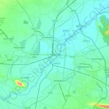
Name: Tirunelveli topographic map, elevation, terrain.
Location: Tirunelveli, Tamil Nadu, 627001, India (8.67869 77.65278 8.77864 77.77055)
Average elevation: 157 ft
Minimum elevation: 89 ft
Maximum elevation: 466 ft
Make a donation
Gear up for your next adventure:
As an Amazon Associate, this site earns from qualifying purchases at no extra cost to you.
Other topographic maps
Click on a map to view its topography, its elevation and its terrain.
Tirunelveli
India > Tamil Nadu > Tirunelveli
Tirunelveli is located at 8°43′41.82″N 77°41′43.94″E / 8.7282833°N 77.6955389°E / 8.7282833; 77.6955389, and its average elevation is 47 metres (154 ft). It is located at the southernmost tip of the Deccan plateau. The Tamirabarani River divides the city into the Tirunelveli quarter and…
Average elevation: 197 ft
Make a donation
Gear up for your next adventure:
As an Amazon Associate, this site earns from qualifying purchases at no extra cost to you.