
Make a donation
Gear up for your next adventure:
As an Amazon Associate, this site earns from qualifying purchases at no extra cost to you.
Opdorp topographic map
Click on the map to display elevation.
Make a donation
Gear up for your next adventure:
As an Amazon Associate, this site earns from qualifying purchases at no extra cost to you.
Opdorp
Opdorp kent kleigrond en zandgrond. De hoogte bedraagt 6-12 meter. De belangrijkste waterloop is de Klaverbeek die in noordelijke richting stroomt en, na samenvloeiing met de Lippelose Beek als Vliet naar de Rupel stroomt.
Make a donation
Gear up for your next adventure:
As an Amazon Associate, this site earns from qualifying purchases at no extra cost to you.
About this map
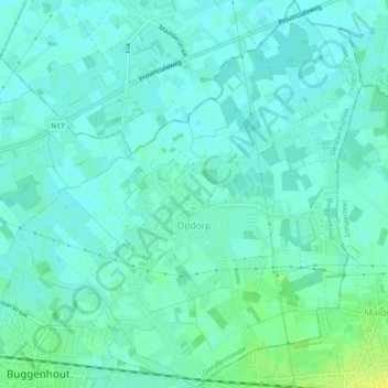
Name: Opdorp topographic map, elevation, terrain.
Average elevation: 23 ft
Minimum elevation: 7 ft
Maximum elevation: 62 ft
Make a donation
Gear up for your next adventure:
As an Amazon Associate, this site earns from qualifying purchases at no extra cost to you.
Other topographic maps
Click on a map to view its topography, its elevation and its terrain.
Hondenlosloopzone Buggenhoutbos
België > Oost-Vlaanderen > Dendermonde > Buggenhout
Average elevation: 69 ft