Geolocate

Mammoth Spring topographic map

Click on the map to display elevation.

About this map

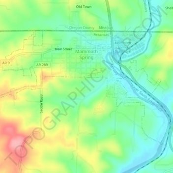
Name: Mammoth Spring topographic map, elevation, terrain.

Location: Mammoth Spring, Fulton County, Arkansas, United States (36.47730 -91.56491 36.49926 -91.52289)

Average elevation: 610 ft

Minimum elevation: 472 ft

Maximum elevation: 833 ft

Fulton County trails, hiking, mountain biking, running and outdoor activities

Other topographic maps

Click on a map to view its topography, its elevation and its terrain.

Elizabeth

United States > Arkansas > Fulton County

Average elevation: 764 ft

Gear up for your next adventure:

🚑Emergency Bivvies - Heat-reflective sleeping bags for survival situations
🕶️GPS Smartphone Mount - Secure mount for phone navigation
📚USA Hiking Guide Books - Top trail guides and map books
🔭Stargazing Telescopes - Perfect for camping in low-light pollution areas shown on maps
🦶Carbon Trekking Poles - Reduce knee impact on steep descents with ultra-light poles

As an Amazon Associate, this site earns from qualifying purchases at no extra cost to you.