
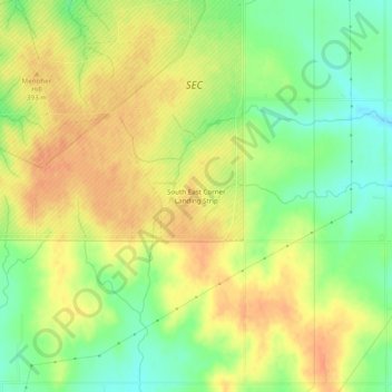
South East Corner Landing Strip topographic map
Interactive map
Click on the map to display elevation.
About this map
Name: South East Corner Landing Strip topographic map, elevation, terrain.
Average elevation: 1,257 ft
Minimum elevation: 1,181 ft
Maximum elevation: 1,309 ft
Other topographic maps
Click on a map to view its topography, its elevation and its terrain.
Daly Hill
United States > Oklahoma > Comanche County
Daly Hill, Comanche County, Oklahoma, United States
Average elevation: 1,299 ft
Jackson Hole
United States > Oklahoma > Comanche County
Jackson Hole, Comanche County, Oklahoma, United States
Average elevation: 1,332 ft
Mount McKinley
United States > Oklahoma > Comanche County
Mount McKinley, Comanche County, Oklahoma, United States
Average elevation: 1,634 ft
Fort Sill
United States > Oklahoma > Comanche County
Fort Sill, Comanche County, Oklahoma, United States
Average elevation: 1,368 ft
Medicine Park
United States > Oklahoma > Comanche County > Medicine Park
Medicine Park, Comanche County, Oklahoma, 73557, United States
Average elevation: 1,407 ft
Lawton
United States > Oklahoma > Comanche County
Lawton, Comanche County, Oklahoma, United States
Average elevation: 1,155 ft