
Make a donation
Gear up for your next adventure:
As an Amazon Associate, this site earns from qualifying purchases at no extra cost to you.
Daly Hill topographic map
Click on the map to display elevation.
Make a donation
Gear up for your next adventure:
As an Amazon Associate, this site earns from qualifying purchases at no extra cost to you.
About this map
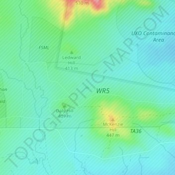
Name: Daly Hill topographic map, elevation, terrain.
Location: Daly Hill, Comanche County, Oklahoma, United States (34.65859 -98.48996 34.65899 -98.48926)
Average elevation: 1,299 ft
Minimum elevation: 1,217 ft
Maximum elevation: 1,575 ft
Make a donation
Gear up for your next adventure:
As an Amazon Associate, this site earns from qualifying purchases at no extra cost to you.
Other topographic maps
Click on a map to view its topography, its elevation and its terrain.
Wichita Mountains National Wildlife Refuge
United States > Oklahoma > Comanche County > Medicine Park
Average elevation: 1,634 ft
Lawton
United States > Oklahoma > Comanche County
Developed on former reservation lands of the Kiowa, Comanche, and Apache Indians, Lawton was founded by European Americans on 6 August 1901. It was named after Major General Henry Ware Lawton, who served in the Civil War, where he earned the Medal of Honor, and was killed in action in the Philippine–American…
Average elevation: 1,155 ft
Make a donation
Gear up for your next adventure:
As an Amazon Associate, this site earns from qualifying purchases at no extra cost to you.
Wichita Mountains Wildlife Refuge
United States > Oklahoma > Comanche County
Average elevation: 1,942 ft
Make a donation
Gear up for your next adventure:
As an Amazon Associate, this site earns from qualifying purchases at no extra cost to you.
Lawton
United States > Oklahoma > Comanche County
Developed on former reservation lands of the Kiowa, Comanche, and Apache peoples, Lawton was incorporated in 1901. It was named after Major General Henry Ware Lawton, who served in the Civil War, where he earned the Medal of Honor, and was killed in action in the Philippine–American War. Lawton's landscape…
Average elevation: 1,155 ft
South East Corner Landing Strip
United States > Oklahoma > Comanche County
Average elevation: 1,257 ft
Make a donation
Gear up for your next adventure:
As an Amazon Associate, this site earns from qualifying purchases at no extra cost to you.