
Make a donation
Gear up for your next adventure:
As an Amazon Associate, this site earns from qualifying purchases at no extra cost to you.
Mikulov topographic map
Click on the map to display elevation.
Make a donation
Gear up for your next adventure:
As an Amazon Associate, this site earns from qualifying purchases at no extra cost to you.
Mikulov
Mikulov lies mostly in the Mikulov Highlands, but the municipal territory also extends into the Lower Morava Valley on the east and into the Dyje–Svratka Valley on the west. The highest point is the hill Turold with an elevation of 385 metres (1,263 ft). Most of the territory lies within the Pálava Protected Landscape Area.
Make a donation
Gear up for your next adventure:
As an Amazon Associate, this site earns from qualifying purchases at no extra cost to you.
About this map
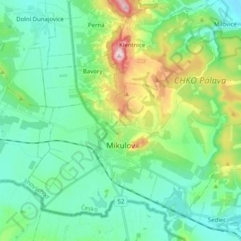
Name: Mikulov topographic map, elevation, terrain.
Average elevation: 771 ft
Minimum elevation: 535 ft
Maximum elevation: 1,493 ft
Make a donation
Gear up for your next adventure:
As an Amazon Associate, this site earns from qualifying purchases at no extra cost to you.
Other topographic maps
Click on a map to view its topography, its elevation and its terrain.