Geolocate

Mones topographic map

Click on the map to display elevation.

About this map

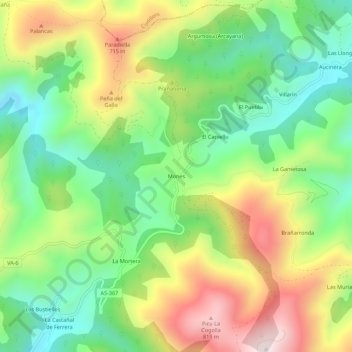
Name: Mones topographic map, elevation, terrain.

Location: Mones, Valdés, Asturias, Spain (43.48556 -6.36014 43.52556 -6.32014)

Average elevation: 1,552 ft

Minimum elevation: 692 ft

Maximum elevation: 2,805 ft

Gear up for your next adventure:

🩹Survival Bandages - High‑quality bandages for emergencies
⛑️Personal Locator Beacon - Safety beacon for emergencies
🔥Fast-Boil Camping Stoves - Efficient cooking systems for quick trail meals
🧤Hiking Gloves - Protective gloves for rugged trails
👟Men's Trail Runners - Lightweight footwear for fast-paced exploration and light hiking

As an Amazon Associate, this site earns from qualifying purchases at no extra cost to you.