
Make a donation
Gear up for your next adventure:
As an Amazon Associate, this site earns from qualifying purchases at no extra cost to you.
Corgo topographic map
Click on the map to display elevation.
Make a donation
Gear up for your next adventure:
As an Amazon Associate, this site earns from qualifying purchases at no extra cost to you.
Corgo
El relieve del municipio es ondulado, con elevaciones y valles que forman los numerosos ríos y arroyos que lo atraviesan. Su río principal es el Miño, que hace de límite con Lugo por el suroeste, y los complementarios son el Chamoso, Tórdea, Neira, Romeán y Riobó, entre otros. Las elevaciones más destacadas son Pena Curral (789 m), Pena da Cruz (747 m) Pena do Picato (637 m) y Castro de Vigo (603 m). La altitud oscila entre los 789 metros al este y los 357 metros a orillas del Miño. El pueblo se alza a 430 metros sobre el nivel del mar.
Make a donation
Gear up for your next adventure:
As an Amazon Associate, this site earns from qualifying purchases at no extra cost to you.
About this map
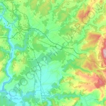
Name: Corgo topographic map, elevation, terrain.
Location: Corgo, Lugo, Galicia, España (42.85815 -7.53617 43.00665 -7.31424)
Average elevation: 1,529 ft
Minimum elevation: 1,129 ft
Maximum elevation: 2,543 ft
Make a donation
Gear up for your next adventure:
As an Amazon Associate, this site earns from qualifying purchases at no extra cost to you.
Other topographic maps
Click on a map to view its topography, its elevation and its terrain.
Make a donation
Gear up for your next adventure:
As an Amazon Associate, this site earns from qualifying purchases at no extra cost to you.
Make a donation
Gear up for your next adventure:
As an Amazon Associate, this site earns from qualifying purchases at no extra cost to you.
Make a donation
Gear up for your next adventure:
As an Amazon Associate, this site earns from qualifying purchases at no extra cost to you.
Make a donation
Gear up for your next adventure:
As an Amazon Associate, this site earns from qualifying purchases at no extra cost to you.
Make a donation
Gear up for your next adventure:
As an Amazon Associate, this site earns from qualifying purchases at no extra cost to you.
Make a donation
Gear up for your next adventure:
As an Amazon Associate, this site earns from qualifying purchases at no extra cost to you.
Serra do Careón
España > Galicia > Lugo > Friol
Con una altitud media de 550 metros y máxima de 798 metros, en el monte Careón. Dominan los granitos intrusivos, gneis de "ojo de sapo" y esquistos. En esta sierra nacen el río Narla, afluente del Miño, y el río Pambre, el río Seco y el río Furelos, afluentes los tres del río Ulla.
Average elevation: 2,395 ft
Make a donation
Gear up for your next adventure:
As an Amazon Associate, this site earns from qualifying purchases at no extra cost to you.
Make a donation
Gear up for your next adventure:
As an Amazon Associate, this site earns from qualifying purchases at no extra cost to you.
Make a donation
Gear up for your next adventure:
As an Amazon Associate, this site earns from qualifying purchases at no extra cost to you.
Make a donation
Gear up for your next adventure:
As an Amazon Associate, this site earns from qualifying purchases at no extra cost to you.
Make a donation
Gear up for your next adventure:
As an Amazon Associate, this site earns from qualifying purchases at no extra cost to you.
Make a donation
Gear up for your next adventure:
As an Amazon Associate, this site earns from qualifying purchases at no extra cost to you.
Make a donation
Gear up for your next adventure:
As an Amazon Associate, this site earns from qualifying purchases at no extra cost to you.