
Shotesham topographic map
Click on the map to display elevation.
About this map
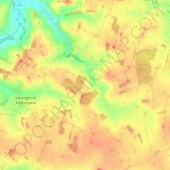
Name: Shotesham topographic map, elevation, terrain.
Location: Shotesham, South Norfolk, Norfolk, England, United Kingdom (52.50583 1.26802 52.55789 1.35076)
Average elevation: 118 ft
Minimum elevation: 23 ft
Maximum elevation: 171 ft
Other topographic maps
Click on a map to view its topography, its elevation and its terrain.
Poringland Wood
United Kingdom > England > Norfolk > South Norfolk > Framingham Earl
Average elevation: 164 ft
Fundenhall
United Kingdom > England > Norfolk > South Norfolk > Ashwellthorpe and Fundenhall
Average elevation: 164 ft
Highoak
United Kingdom > England > Norfolk > South Norfolk > Morley St Botolph
Average elevation: 154 ft
Forncett End
United Kingdom > England > Norfolk > South Norfolk > Tacolneston
Average elevation: 174 ft
Beckhithe
United Kingdom > England > Norfolk > South Norfolk > Little Melton > Beckhithe
Average elevation: 121 ft
Forncett Saint Mary
United Kingdom > England > Norfolk > South Norfolk > Forncett St Peter
Average elevation: 141 ft