Geolocate

Amanda topographic map

Click on the map to display elevation.

About this map

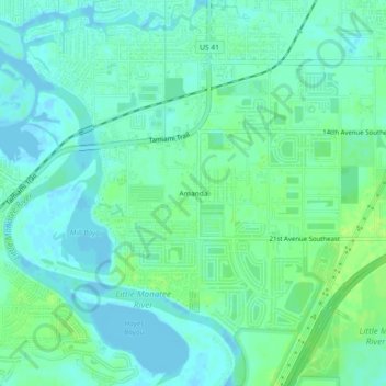
Name: Amanda topographic map, elevation, terrain.

Location: Amanda, Hillsborough County, Florida, 33570, United States (27.67951 -82.45591 27.71951 -82.41591)

Average elevation: 16 ft

Minimum elevation: -10 ft

Maximum elevation: 39 ft

Hillsborough County trails, hiking, mountain biking, running and outdoor activities

Other topographic maps

Click on a map to view its topography, its elevation and its terrain.

Lutz

United States > Florida > Hillsborough County

Average elevation: 69 ft

Dover

United States > Florida > Hillsborough County > Brandon > Aarons Place

Average elevation: 108 ft

Mango

United States > Florida > Hillsborough County

Average elevation: 62 ft

Cheval

United States > Florida > Hillsborough County

Average elevation: 66 ft

Lake Park

United States > Florida > Hillsborough County > Lutz

Average elevation: 62 ft

Northdale

United States > Florida > Hillsborough County > Cheval

Average elevation: 62 ft

Boyette

United States > Florida > Hillsborough County > Boyette

Average elevation: 69 ft

Gear up for your next adventure:

🧥Men's Rain Shells - Premium waterproof and breathable jackets for mountain weather
🛰️Handheld GPS Units - Professional satellite navigators for precise backcountry mapping
🔊Portable Camp Speaker - Music and alerts at camp
🌧️Backpack Rain Cover - Keep gear dry in wet weather
🧭Pro Hiking Compasses - High-accuracy liquid-filled compasses for topographic orientation

As an Amazon Associate, this site earns from qualifying purchases at no extra cost to you.