Geolocate

Le Verdier topographic map

Click on the map to display elevation.

About this map

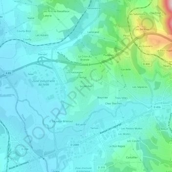
Name: Le Verdier topographic map, elevation, terrain.

Location: Le Verdier, Thiers, Puy-de-Dôme, Auvergne-Rhône-Alpes, France métropolitaine, 63300, France (45.83563 3.49612 45.87563 3.53612)

Average elevation: 1,099 ft

Minimum elevation: 928 ft

Maximum elevation: 1,926 ft

Other topographic maps

Click on a map to view its topography, its elevation and its terrain.

63300

France > Auvergne-Rhône-Alpes > Puy-de-Dôme > Thiers > Faux Martel

Average elevation: 1,381 ft

Gear up for your next adventure:

❄️Traction Cleats - Prevent slips on icy trails during winter hikes
🪶LED Camping Lantern - Bright lantern for camp lighting
🛏️Cold Weather Sleeping Bag - Warm sleeping bag for cold conditions
🪶Trail Camera - Capture wildlife on your hikes
👖Convertible Hiking Pants - Versatile zip-off pants for changing altitudes and temperatures

As an Amazon Associate, this site earns from qualifying purchases at no extra cost to you.