Geolocate

Ocho Rios topographic map

Click on the map to display elevation.

About this map

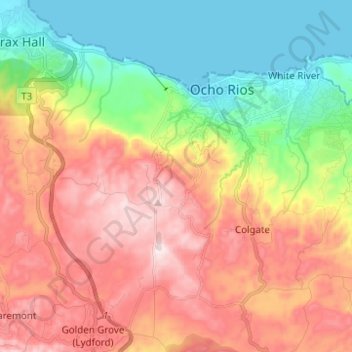
Name: Ocho Rios topographic map, elevation, terrain.

Location: Ocho Rios, Saint Ann, Middlesex County, Jamaica (18.33532 -77.16602 18.42310 -77.04242)

Average elevation: 906 ft

Minimum elevation: 0 ft

Maximum elevation: 1,939 ft

Other topographic maps

Click on a map to view its topography, its elevation and its terrain.

Green Park

Jamaica > Saint Ann > Ocho Rios

Average elevation: 1,516 ft

New Hope

Jamaica > Saint Ann > Ocho Rios

Average elevation: 860 ft

Gear up for your next adventure:

🪶Fire Starter Kit - Reliable fire starter for survival and camping
🧷Carabiner Set - Durable clips for gear attachment
🦶Hiking Gaiters - Keep debris and water out of your boots
🪄Magnetic Compass - Accurate compass for navigation
🌧️Backpack Rain Cover - Keep gear dry in wet weather

As an Amazon Associate, this site earns from qualifying purchases at no extra cost to you.