
Make a donation
Gear up for your next adventure:
As an Amazon Associate, this site earns from qualifying purchases at no extra cost to you.
Pietreni topographic map
Click on the map to display elevation.
Make a donation
Gear up for your next adventure:
As an Amazon Associate, this site earns from qualifying purchases at no extra cost to you.
About this map
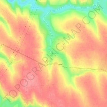
Name: Pietreni topographic map, elevation, terrain.
Location: Pietreni, Deleni, Constanța, 907112, Romania (44.07553 28.04612 44.11553 28.08612)
Average elevation: 400 ft
Minimum elevation: 200 ft
Maximum elevation: 502 ft
Make a donation
Gear up for your next adventure:
As an Amazon Associate, this site earns from qualifying purchases at no extra cost to you.
Other topographic maps
Click on a map to view its topography, its elevation and its terrain.
Make a donation
Gear up for your next adventure:
As an Amazon Associate, this site earns from qualifying purchases at no extra cost to you.
Mangalia
Mangalia is positioned at 43°49’ latitude and 28°35’ longitude, with an approximate elevation of 10 meters, 44 kilometres (27 miles) south of the municipality of Constanţa, on the same latitude as the French resort of Nice. Mangalia is one of the southernmost resorts on the Romanian coast of the Black Sea.
Average elevation: 59 ft
Make a donation
Gear up for your next adventure:
As an Amazon Associate, this site earns from qualifying purchases at no extra cost to you.
Make a donation
Gear up for your next adventure:
As an Amazon Associate, this site earns from qualifying purchases at no extra cost to you.
Make a donation
Gear up for your next adventure:
As an Amazon Associate, this site earns from qualifying purchases at no extra cost to you.
Techirghiol
Town is in the south east extremity of Romania (Constanța County), situated on the north west shore of Lake Techirghiol (11.6 km2), elevation 15–20 m, 18 km south of the municipality of Constanța and very close to the Black Sea (3 km).
Average elevation: 75 ft
Make a donation
Gear up for your next adventure:
As an Amazon Associate, this site earns from qualifying purchases at no extra cost to you.
Make a donation
Gear up for your next adventure:
As an Amazon Associate, this site earns from qualifying purchases at no extra cost to you.
Make a donation
Gear up for your next adventure:
As an Amazon Associate, this site earns from qualifying purchases at no extra cost to you.