
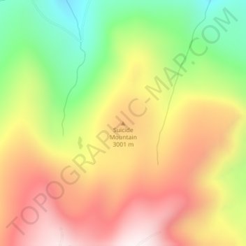
Suicide Mountain topographic map
Interactive map
Click on the map to display elevation.
About this map
Name: Suicide Mountain topographic map, elevation, terrain.
Location: Suicide Mountain, Eagle County, Colorado, United States (39.53105 -106.96926 39.53115 -106.96916)
Average elevation: 9,465 ft
Minimum elevation: 8,140 ft
Maximum elevation: 10,682 ft
Other topographic maps
Click on a map to view its topography, its elevation and its terrain.
Vail
United States > Colorado > Eagle County
Vail, Eagle County, Colorado, 81657, United States
Average elevation: 9,688 ft
Fulford
United States > Colorado > Eagle County
Fulford, Eagle County, Colorado, 81658, United States
Average elevation: 10,213 ft
Gypsum
United States > Colorado > Eagle County
Gypsum, Eagle County, Colorado, United States
Average elevation: 7,133 ft
Mystic Island Lake
United States > Colorado > Eagle County
Mystic Island Lake, Eagle County, Colorado, United States
Average elevation: 11,939 ft
Wedding Island
United States > Colorado > Eagle County > Vail
Wedding Island, Vail, Eagle County, Colorado, United States
Average elevation: 9,213 ft
Climax-Moly Number 4 Dam
United States > Colorado > Eagle County
Climax-Moly Number 4 Dam, Eagle County, Colorado, United States
Average elevation: 10,988 ft
Avon
United States > Colorado > Eagle County
Avon, Eagle County, Colorado, 81620, United States
Average elevation: 8,596 ft
Beaver Creek
United States > Colorado > Eagle County
Beaver Creek, Eagle County, Colorado, 81260, United States
Average elevation: 8,543 ft
Mount Jackson
United States > Colorado > Eagle County
Mount Jackson, Eagle County, Colorado, United States
Average elevation: 12,218 ft
Edwards
United States > Colorado > Eagle County > Edwards
Edwards, Eagle County, Colorado, 81632, United States
Average elevation: 8,524 ft
Mount of the Holy Cross
United States > Colorado > Eagle County
Mount of the Holy Cross, Eagle County, Colorado, United States
Average elevation: 12,441 ft