
Thank you for supporting this site ❤️
Make a donation
Make a donation
Gear up for your next adventure:
As an Amazon Associate, this site earns from qualifying purchases at no extra cost to you.
Geeneinde topographic map
Click on the map to display elevation.
Thank you for supporting this site ❤️
Make a donation
Make a donation
Gear up for your next adventure:
As an Amazon Associate, this site earns from qualifying purchases at no extra cost to you.
About this map
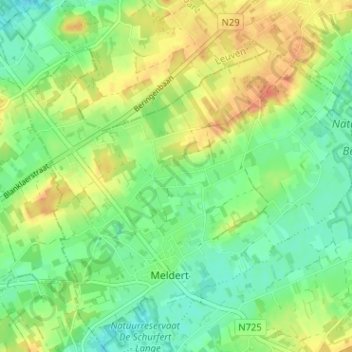
Name: Geeneinde topographic map, elevation, terrain.
Location: Geeneinde, Meldert, Lummen, Hasselt, Limburg, 3560, België (50.98993 5.12310 51.02993 5.16310)
Average elevation: 112 ft
Minimum elevation: 49 ft
Maximum elevation: 190 ft
Thank you for supporting this site ❤️
Make a donation
Make a donation
Gear up for your next adventure:
As an Amazon Associate, this site earns from qualifying purchases at no extra cost to you.