
Make a donation
Gear up for your next adventure:
As an Amazon Associate, this site earns from qualifying purchases at no extra cost to you.
Beeville topographic map
Click on the map to display elevation.
Make a donation
Gear up for your next adventure:
As an Amazon Associate, this site earns from qualifying purchases at no extra cost to you.
About this map
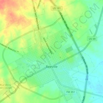
Name: Beeville topographic map, elevation, terrain.
Location: Beeville, Bee County, Texas, United States (28.37887 -97.77686 28.44103 -97.72533)
Average elevation: 246 ft
Minimum elevation: 187 ft
Maximum elevation: 341 ft
Bee County trails, hiking, mountain biking, running and outdoor activities
Make a donation
Gear up for your next adventure:
As an Amazon Associate, this site earns from qualifying purchases at no extra cost to you.
Other topographic maps
Click on a map to view its topography, its elevation and its terrain.
Old Houston Highway Colonia
United States > Texas > Bee County > Old Houston Highway Colonia
Average elevation: 226 ft
Make a donation
Gear up for your next adventure:
As an Amazon Associate, this site earns from qualifying purchases at no extra cost to you.