
Make a donation
Gear up for your next adventure:
As an Amazon Associate, this site earns from qualifying purchases at no extra cost to you.
Egem topographic map
Click on the map to display elevation.
Make a donation
Gear up for your next adventure:
As an Amazon Associate, this site earns from qualifying purchases at no extra cost to you.
Egem
Egem ligt in Zandlemig Vlaanderen en wel op een uitloper van het Plateau van Tielt, op een hoogte van 25 meter (bij de samenvloeiing van de Ringbeek en de Veldekensbeek) tot 50 meter (bij Egemkapelle). De dorpskom ligt op ongeveer 42,5 meter hoogte.
Make a donation
Gear up for your next adventure:
As an Amazon Associate, this site earns from qualifying purchases at no extra cost to you.
About this map
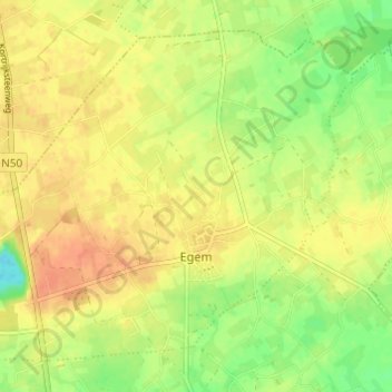
Name: Egem topographic map, elevation, terrain.
Location: Egem, Pittem, Tielt, West-Vlaanderen, Vlaanderen, België (51.00471 3.22275 51.03691 3.28367)
Average elevation: 112 ft
Minimum elevation: 36 ft
Maximum elevation: 164 ft
Make a donation
Gear up for your next adventure:
As an Amazon Associate, this site earns from qualifying purchases at no extra cost to you.
Other topographic maps
Click on a map to view its topography, its elevation and its terrain.
Make a donation
Gear up for your next adventure:
As an Amazon Associate, this site earns from qualifying purchases at no extra cost to you.