
Make a donation
Gear up for your next adventure:
As an Amazon Associate, this site earns from qualifying purchases at no extra cost to you.
Leimakhong topographic map
Click on the map to display elevation.
Make a donation
Gear up for your next adventure:
As an Amazon Associate, this site earns from qualifying purchases at no extra cost to you.
About this map
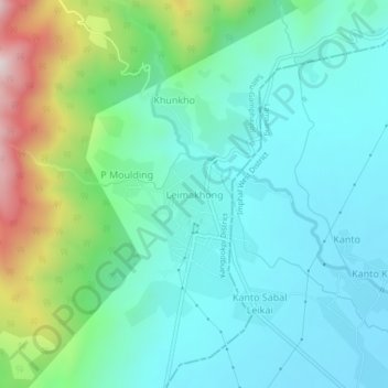
Name: Leimakhong topographic map, elevation, terrain.
Location: Leimakhong, Kangpokpi district, Manipur, 795136, India (24.92297 93.81987 24.96297 93.85987)
Average elevation: 3,173 ft
Minimum elevation: 2,661 ft
Maximum elevation: 4,803 ft
Make a donation
Gear up for your next adventure:
As an Amazon Associate, this site earns from qualifying purchases at no extra cost to you.
Other topographic maps
Click on a map to view its topography, its elevation and its terrain.
Loktak Lake
India > Manipur > Bishnupur > Thanga
At the Ithai barrage outlet of the Lake, the direct catchment area draining into the lake is 980 km2 (380 sq mi) out of which 430 km2 (170 sq mi) is under paddy cultivation, 150 km2 (58 sq mi) under habitation and 400 km2 (150 sq mi) under forest cover. The area of the lake is 236.21 km2 (91.20 sq mi),…
Average elevation: 2,533 ft
Make a donation
Gear up for your next adventure:
As an Amazon Associate, this site earns from qualifying purchases at no extra cost to you.