
Make a donation
Gear up for your next adventure:
As an Amazon Associate, this site earns from qualifying purchases at no extra cost to you.
Singorojo topographic map
Click on the map to display elevation.
Make a donation
Gear up for your next adventure:
As an Amazon Associate, this site earns from qualifying purchases at no extra cost to you.
About this map
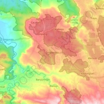
Name: Singorojo topographic map, elevation, terrain.
Location: Singorojo, Kendal, Central Java, Java, Indonesia (-7.12699 110.18109 -7.04699 110.26109)
Average elevation: 820 ft
Minimum elevation: 207 ft
Maximum elevation: 1,322 ft
Make a donation
Gear up for your next adventure:
As an Amazon Associate, this site earns from qualifying purchases at no extra cost to you.
Other topographic maps
Click on a map to view its topography, its elevation and its terrain.
Taman Alun-Alun Kaliwungu
Indonesia > Central Java > Kendal > Kendal > Sikopek Kulon
Average elevation: 49 ft
Taman Kantor Kecamatan Kaliwungu
Indonesia > Central Java > Kendal > Kendal > Sikopek Kulon
Average elevation: 26 ft