
Make a donation
Gear up for your next adventure:
As an Amazon Associate, this site earns from qualifying purchases at no extra cost to you.
Garenfeld topographic map
Click on the map to display elevation.
Make a donation
Gear up for your next adventure:
As an Amazon Associate, this site earns from qualifying purchases at no extra cost to you.
Garenfeld
Garenfeld weist mit dem Jahresende 2012 eine Einwohnerzahl von 1576 Personen auf, das sind 1,2 Prozent weniger als Ende 2002, während gleichzeitig die Einwohnerzahl der Stadt Hagen um 7,5 Prozent zurückgegangen ist. Der Ausländeranteil liegt mit 2,2 Prozent (Hagen 13,8) und der Migrantenanteil mit 14 Prozent (Hagen 37,3) verhältnismäßig niedrig. Demgegenüber liegt der Altersdurchschnitt mit 46,4 Jahren höher als der Altersdurchschnitt von Hagen mit 44,7 Jahren.
Make a donation
Gear up for your next adventure:
As an Amazon Associate, this site earns from qualifying purchases at no extra cost to you.
About this map
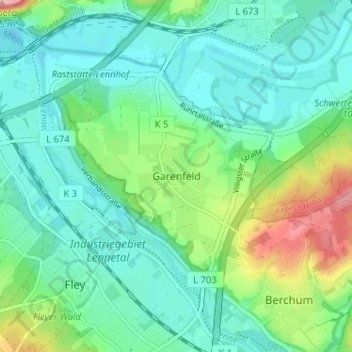
Name: Garenfeld topographic map, elevation, terrain.
Location: Garenfeld, Hagen, Nordrhein-Westfalen, 58093, Deutschland (51.38050 7.49767 51.42050 7.53767)
Average elevation: 420 ft
Minimum elevation: 302 ft
Maximum elevation: 771 ft
Make a donation
Gear up for your next adventure:
As an Amazon Associate, this site earns from qualifying purchases at no extra cost to you.
Other topographic maps
Click on a map to view its topography, its elevation and its terrain.
Hohenlimburg
Deutschland > Nordrhein-Westfalen > Hagen
Da die Grafen zu Bentheim-Tecklenburg Anfang des 18. Jahrhunderts durch den jahrelangen Rechtsstreit mit dem Haus Solms-Braunfels um den Besitz der Grafschaft Tecklenburg hoch verschuldet waren, entsprachen sie gern der Bitte ihrer „Untertanen“, da sie sich höhere Einnahmen an Steuern und Abgaben…
Average elevation: 778 ft
Garenfeld
Deutschland > Nordrhein-Westfalen > Hagen
Garenfeld wies mit dem Jahresende 2012 eine Einwohnerzahl von 1576 Personen auf, das waren 1,2 % weniger als Ende 2002, während gleichzeitig die Einwohnerzahl der Stadt Hagen um 7,5 % zurückgegangen war. Der Ausländeranteil lag mit 2,2 % (Hagen 13,8 %) und der Migrantenanteil mit 14 % (Hagen 37,3 %)…
Average elevation: 420 ft
Make a donation
Gear up for your next adventure:
As an Amazon Associate, this site earns from qualifying purchases at no extra cost to you.
Make a donation
Gear up for your next adventure:
As an Amazon Associate, this site earns from qualifying purchases at no extra cost to you.
Unter den Eichen
Deutschland > Nordrhein-Westfalen > Hagen > Unter den Eichen
Average elevation: 482 ft
Make a donation
Gear up for your next adventure:
As an Amazon Associate, this site earns from qualifying purchases at no extra cost to you.