
Għasri topographic map
Interactive map
Click on the map to display elevation.
About this map
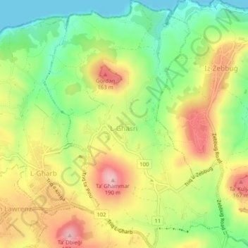
Name: Għasri topographic map, elevation, terrain.
Location: Għasri, Gozo Region, GSR 1250, Malta (36.05029 14.20921 36.08179 14.23751)
Average elevation: 295 ft
Minimum elevation: 0 ft
Maximum elevation: 627 ft
Other topographic maps
Click on a map to view its topography, its elevation and its terrain.
Kemmuna
Malta > Gozo Region > Għajnsielem
Kemmuna, Għajnsielem, Gozo Region, Malta
Average elevation: 33 ft