Geolocate

Kemmuna topographic map

Click on the map to display elevation.

About this map

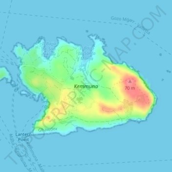
Name: Kemmuna topographic map, elevation, terrain.

Location: Kemmuna, Għajnsielem, Gozo Region, Malta (36.00380 14.32243 36.02006 14.35079)

Average elevation: 33 ft

Minimum elevation: 0 ft

Maximum elevation: 243 ft

Gear up for your next adventure:

📷Action Cameras - Rugged cameras to document your journeys across rugged terrain
🪵Folding Camp Saw - Compact saw for wood and campsite work
🎒Gear Packing Cubes - Organize your backpack efficiently
🌡️Portable Weather Meter - Track weather conditions on the trail
🎒Hydration Pack - Hands‑free water reservoir for long hikes

As an Amazon Associate, this site earns from qualifying purchases at no extra cost to you.