
Thank you for supporting this site ❤️
Make a donation
Make a donation
Gear up for your next adventure:
As an Amazon Associate, this site earns from qualifying purchases at no extra cost to you.
Valtenna topographic map
Click on the map to display elevation.
Thank you for supporting this site ❤️
Make a donation
Make a donation
Gear up for your next adventure:
As an Amazon Associate, this site earns from qualifying purchases at no extra cost to you.
About this map
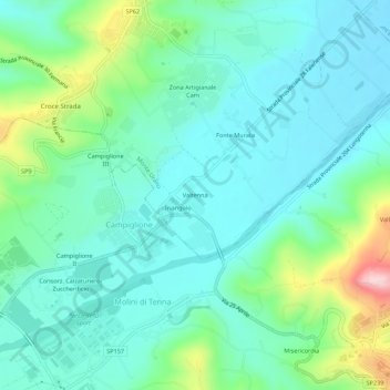
Name: Valtenna topographic map, elevation, terrain.
Location: Valtenna, Monte Urano, Fermo, Marche, 63813, Italia (43.15983 13.65926 43.19983 13.69926)
Average elevation: 348 ft
Minimum elevation: 144 ft
Maximum elevation: 1,024 ft
Thank you for supporting this site ❤️
Make a donation
Make a donation
Gear up for your next adventure:
As an Amazon Associate, this site earns from qualifying purchases at no extra cost to you.