
Make a donation
Gear up for your next adventure:
As an Amazon Associate, this site earns from qualifying purchases at no extra cost to you.
Le Vigan topographic map
Click on the map to display elevation.
Make a donation
Gear up for your next adventure:
As an Amazon Associate, this site earns from qualifying purchases at no extra cost to you.
About this map
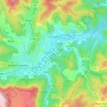
Name: Le Vigan topographic map, elevation, terrain.
Location: Le Vigan, Gard, Occitania, Metropolitan France, 30120, France (43.95510 3.59180 44.00846 3.67520)
Average elevation: 1,296 ft
Minimum elevation: 646 ft
Maximum elevation: 2,631 ft
Make a donation
Gear up for your next adventure:
As an Amazon Associate, this site earns from qualifying purchases at no extra cost to you.
Other topographic maps
Click on a map to view its topography, its elevation and its terrain.
Make a donation
Gear up for your next adventure:
As an Amazon Associate, this site earns from qualifying purchases at no extra cost to you.
La Bégude de Vers-Pont-du-Gard
France > Occitania > Gard > Vers-Pont-du-Gard
Average elevation: 187 ft