
City of Wetaskiwin topographic map
Interactive map
Click on the map to display elevation.
About this map
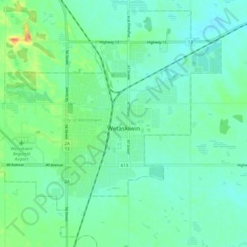
Name: City of Wetaskiwin topographic map, elevation, terrain.
Location: City of Wetaskiwin, Division No. 11, Alberta, Canada (52.94288 -113.42641 52.99623 -113.32960)
Average elevation: 2,493 ft
Minimum elevation: 2,457 ft
Maximum elevation: 2,589 ft
Other topographic maps
Click on a map to view its topography, its elevation and its terrain.
Sherwood Park
Canada > Alberta > Division No. 11
Sherwood Park, Division No. 11, Alberta, Canada
Average elevation: 2,267 ft
Fort Saskachewan
Canada > Alberta > Division No. 11
Fort Saskachewan, Division No. 11, Alberta, Canada
Average elevation: 2,090 ft
City of Leduc
Canada > Alberta > Division No. 11
City of Leduc, Division No. 11, Alberta, Canada
Average elevation: 2,385 ft
Chappelle
Canada > Alberta > Division No. 11
Chappelle, Heritage Valley, Division No. 11, Alberta, Canada
Average elevation: 2,280 ft
Nisku
Canada > Alberta > Division No. 11
Nisku, Division No. 11, Alberta, T9E 0W8, Canada
Average elevation: 2,343 ft
City of Spruce Grove
Canada > Alberta > Division No. 11
City of Spruce Grove, Division No. 11, Alberta, Canada
Average elevation: 2,293 ft