Geolocate

Lundy topographic map

Click on the map to display elevation.

👉 Easily get elevation data in JSON, GeoTIFF and KML formats using Elevation API
Thank you for supporting this site ❤️
Make a donation

About this map

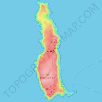
Name: Lundy topographic map, elevation, terrain.

Location: Lundy, Torridge District, Devon, England, EX39 2LY, United Kingdom (51.15849 -4.68061 51.20252 -4.65310)

Average elevation: 52 ft

Minimum elevation: 0 ft

Maximum elevation: 472 ft

Other topographic maps

Click on a map to view its topography, its elevation and its terrain.

Earthquake

United Kingdom > England > Devon > Torridge District

Average elevation: 115 ft

Clawton

United Kingdom > England > Devon > Torridge District

Average elevation: 420 ft

Riddlecombe

United Kingdom > England > Devon > Torridge District

Average elevation: 512 ft

Derril

United Kingdom > England > Devon > Torridge District > Pyworthy

Average elevation: 417 ft

Westward Ho!

United Kingdom > England > Devon > Torridge District

Average elevation: 75 ft

Chilsworthy

United Kingdom > England > Devon > Torridge District

Average elevation: 456 ft

Venngreen

United Kingdom > England > Devon > Torridge District

Average elevation: 489 ft

Horns Cross

United Kingdom > England > Devon > Torridge District

Average elevation: 367 ft

Taddiport

United Kingdom > England > Devon > Torridge District

Average elevation: 279 ft

Stibb Cross

United Kingdom > England > Devon > Torridge District

Average elevation: 515 ft

Ashmill

United Kingdom > England > Devon > Torridge District > Ashwater

Average elevation: 512 ft

Stoke

United Kingdom > England > Devon > Torridge District > Hartland

Average elevation: 249 ft

Woodacott

United Kingdom > England > Devon > Torridge District > Thornbury

Average elevation: 453 ft

Hollocombe

United Kingdom > England > Devon > Torridge District

Average elevation: 489 ft

Appledore

United Kingdom > England > Devon > Torridge District

Average elevation: 62 ft

Churchtown

United Kingdom > England > Devon > Torridge District

Average elevation: 377 ft

Appledore

United Kingdom > England > Devon > Torridge District

Average elevation: 69 ft

Diddywells

United Kingdom > England > Devon > Torridge District > Northam

Average elevation: 62 ft

Gear up for your next adventure:

🪶Compact Camp Shovel - Folding shovel for campsite tasks
🧣Merino Neck Gaiters - Multi-functional headwear for wind and sun protection
🛶Inflatable Kayak - Portable kayak for rivers, lakes, and expeditions
🪶Thermal Camp Blanket - Extra warmth for cold nights
🎁Geography Themed Gifts - Unique gift ideas for map lovers and geography enthusiasts

As an Amazon Associate, this site earns from qualifying purchases at no extra cost to you.