Geolocate

Villaro topographic map

Click on the map to display elevation.

About this map

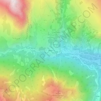
Name: Villaro topographic map, elevation, terrain.

Location: Villaro, Acceglio, Cuneo, Piemonte, 12021, Italia (44.45612 6.95672 44.49612 6.99672)

Average elevation: 5,741 ft

Minimum elevation: 3,855 ft

Maximum elevation: 8,839 ft

Gear up for your next adventure:

🏕️Tent Footprint - Protect your tent base from wear
🏫Relief Map Kits - Hands-on tools for teaching landforms and elevation
🎒Trekking Poles - Sturdy poles for balance and stability on rough terrain
🧷Carabiner Set - Durable clips for gear attachment
🥘Titanium Cookware - Durable, featherlight pots and pans for backpacking

As an Amazon Associate, this site earns from qualifying purchases at no extra cost to you.