
Make a donation
Gear up for your next adventure:
As an Amazon Associate, this site earns from qualifying purchases at no extra cost to you.
Rovio topographic map
Click on the map to display elevation.
Make a donation
Gear up for your next adventure:
As an Amazon Associate, this site earns from qualifying purchases at no extra cost to you.
About this map
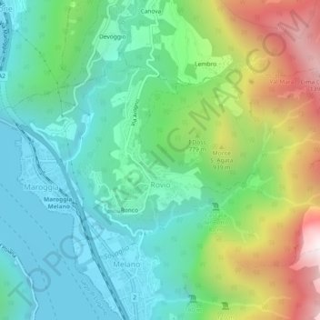
Name: Rovio topographic map, elevation, terrain.
Average elevation: 2,044 ft
Minimum elevation: 856 ft
Maximum elevation: 4,751 ft
Make a donation
Gear up for your next adventure:
As an Amazon Associate, this site earns from qualifying purchases at no extra cost to you.
Other topographic maps
Click on a map to view its topography, its elevation and its terrain.
Monte Generoso
Suisse > Tessin > District de Lugano > Val Mara
Avec Giulio Andreolli, l'architecte suisse Mario Botta a érigé près du sommet, à une altitude de 1 601 m, un restaurant panoramique à cinq niveaux, dit Steinblume ou Fiore di Pietra. Il a été inauguré en présence de l'architecte le 29 mars 2017.
Average elevation: 4,072 ft