
Make a donation
Gear up for your next adventure:
As an Amazon Associate, this site earns from qualifying purchases at no extra cost to you.
Nordhausen topographic map
Click on the map to display elevation.
Make a donation
Gear up for your next adventure:
As an Amazon Associate, this site earns from qualifying purchases at no extra cost to you.
Nordhausen
Nordhausen is situated at the border between the flat and fertile area of Goldene Aue in the south and the foothills of the Harz mountains in the north on a level of approx. 180 m of elevation. The Zorge river crosses the city from northwest to southeast and the bigger Helme river runs in west-eastern direction at the southern border of the municipality. Between them are some quarry ponds of former gravel mining near the Sundhausen and Bielen districts. To the north, the terrain is getting more hilly and part of a karst area south to the Harz mountains. The north-west of the territory is marked by the Kohnstein hill (335 m) and the north-east is the Rüdigsdorf Switzerland, a small area with a beautiful landscape up to 350 m of elevation around Rüdigsdorf district. South of Helme river, the terrain gets also hilly around the Windleite mountains between Nordhausen and Sondershausen. Most of the municipal territory is in agricultural use. The forests are located first between the city centre in the south and Rüdigsdorf in the north (with interruptions), second at Kohnstein hill and third in the east around Rodishain and Stempeda.
Make a donation
Gear up for your next adventure:
As an Amazon Associate, this site earns from qualifying purchases at no extra cost to you.
About this map
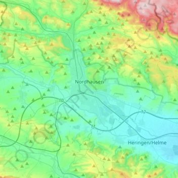
Name: Nordhausen topographic map, elevation, terrain.
Location: Nordhausen, Landkreis Nordhausen, Thuringia, 99734, Germany (51.44048 10.67615 51.55555 10.94790)
Average elevation: 807 ft
Minimum elevation: 512 ft
Maximum elevation: 1,762 ft
Make a donation
Gear up for your next adventure:
As an Amazon Associate, this site earns from qualifying purchases at no extra cost to you.