
Thank you for supporting this site ❤️
Make a donation
Make a donation
Gear up for your next adventure:
As an Amazon Associate, this site earns from qualifying purchases at no extra cost to you.
Pech de Bugarach topographic map
Click on the map to display elevation.
Thank you for supporting this site ❤️
Make a donation
Make a donation
Gear up for your next adventure:
As an Amazon Associate, this site earns from qualifying purchases at no extra cost to you.
Pech de Bugarach
C'est le point culminant du massif des Corbières avec 1 230 mètres d'altitude. De son sommet, le panorama s'étend des Pyrénées à la montagne Noire et de la Méditerranée à la haute vallée de l'Aude.
Thank you for supporting this site ❤️
Make a donation
Make a donation
Gear up for your next adventure:
As an Amazon Associate, this site earns from qualifying purchases at no extra cost to you.
About this map
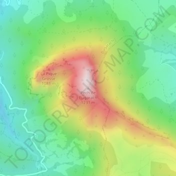
Name: Pech de Bugarach topographic map, elevation, terrain.
Average elevation: 2,520 ft
Minimum elevation: 1,660 ft
Maximum elevation: 3,983 ft
Thank you for supporting this site ❤️
Make a donation
Make a donation
Gear up for your next adventure:
As an Amazon Associate, this site earns from qualifying purchases at no extra cost to you.