Geolocate

Codroipo / Codroip topographic map

Click on the map to display elevation.

About this map
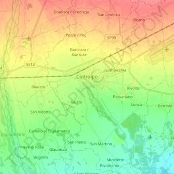
Name: Codroipo / Codroip topographic map, elevation, terrain.

Location: Codroipo / Codroip, Udine, Friuli – Venezia Giulia, 33033, Italy (45.90027 12.90373 46.00888 13.05010)

Average elevation: 135 ft

Minimum elevation: 49 ft

Maximum elevation: 240 ft

Other topographic maps

Click on a map to view its topography, its elevation and its terrain.

Monte Lussari

Italy > Friuli – Venezia Giulia > Udine > Tarvisio

Average elevation: 4,826 ft

Lonca

Italy > Friuli – Venezia Giulia > Udine > Codroipo

Average elevation: 108 ft

Entrampo

Italy > Friuli – Venezia Giulia > Udine > Ovaro

Average elevation: 2,461 ft

Musi / Mužac

Italy > Friuli – Venezia Giulia > Udine

Average elevation: 3,504 ft

Vore

Italy > Friuli – Venezia Giulia > Udine > Fielis > Vit

Average elevation: 2,411 ft

Scale / Skale

Italy > Friuli – Venezia Giulia > Udine > Drenchia

Average elevation: 2,001 ft

Gear up for your next adventure:

🏫Relief Map Kits - Hands-on tools for teaching landforms and elevation
🖼️Topo Map Wall Art - Decorative topographic prints of famous peaks and regions
🪶Camping Sleeping Pad - Comfortable sleeping pad for backpacking
🔋Solar Power Banks - Keep your GPS and phone charged in remote wilderness areas
📱Solar Portable Charger - Solar power bank for charging devices off‑grid

As an Amazon Associate, this site earns from qualifying purchases at no extra cost to you.