
Make a donation
Gear up for your next adventure:
As an Amazon Associate, this site earns from qualifying purchases at no extra cost to you.
Boquerón topographic map
Click on the map to display elevation.
Make a donation
Gear up for your next adventure:
As an Amazon Associate, this site earns from qualifying purchases at no extra cost to you.
About this map
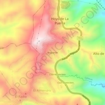
Name: Boquerón topographic map, elevation, terrain.
Average elevation: 3,875 ft
Minimum elevation: 2,621 ft
Maximum elevation: 4,829 ft
Make a donation
Gear up for your next adventure:
As an Amazon Associate, this site earns from qualifying purchases at no extra cost to you.
Other topographic maps
Click on a map to view its topography, its elevation and its terrain.
Cerro El Volcán
Venezuela > Estado Miranda > Municipio Baruta > Caracas > Hoyo de La Puerta
Alcanza una elevación de 1490 metros sobre el nivel del mar, y a pesar de que pudiera indicar su nombre el lugar no tiene un registro de actividad volcánica. Este cerro actúa como cinturón vegetal que surte de aire fresco a los municipios Baruta y El Hatillo. Su geomorfología presenta un paisaje de…
Average elevation: 3,973 ft