
Newton topographic map
Click on the map to display elevation.
About this map
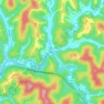
Name: Newton topographic map, elevation, terrain.
Location: Newton, Roane County, West Virginia, 25266, United States (38.57149 -81.19873 38.61149 -81.15873)
Average elevation: 942 ft
Minimum elevation: 689 ft
Maximum elevation: 1,352 ft
Roane County trails, hiking, mountain biking, running and outdoor activities
Other topographic maps
Click on a map to view its topography, its elevation and its terrain.