Geolocate

Ozark topographic map

Click on the map to display elevation.

About this map

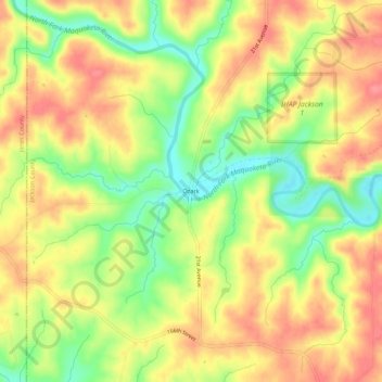
Name: Ozark topographic map, elevation, terrain.

Location: Ozark, Jackson County, Iowa, United States (42.17529 -90.89542 42.21529 -90.85542)

Average elevation: 873 ft

Minimum elevation: 728 ft

Maximum elevation: 981 ft

Jackson County trails, hiking, mountain biking, running and outdoor activities

Other topographic maps

Click on a map to view its topography, its elevation and its terrain.

Bellevue

United States > Iowa > Jackson County

Average elevation: 682 ft

Miles

United States > Iowa > Jackson County

Average elevation: 814 ft

Springbrook

United States > Iowa > Jackson County

Average elevation: 801 ft

Bellevue

United States > Iowa > Jackson County

Average elevation: 682 ft

Springbrook

United States > Iowa > Jackson County

Average elevation: 801 ft

Preston

United States > Iowa > Jackson County

Average elevation: 679 ft

Miles

United States > Iowa > Jackson County

Average elevation: 814 ft

Springbrook

United States > Iowa > Jackson County

Average elevation: 801 ft

Maquoketa

United States > Iowa > Jackson County

Average elevation: 719 ft

Gear up for your next adventure:

🏥Hiking First Aid Kits - Comprehensive medical kits for remote trail injuries
🌲Outdoor Survival Books - Best books on survival skills
🧺Microfiber Travel Towels - Compact and fast-drying towels for trail use
🎒Gear Packing Cubes - Organize your backpack efficiently
Solar GPS Watches - Advanced multisport watches with built-in topographic maps

As an Amazon Associate, this site earns from qualifying purchases at no extra cost to you.