
Kargil topographic map
Click on the map to display elevation.
Kargil
Kargil has an average elevation of 2,676 metres (8,780 feet), and is situated along the banks of the Suru River (Indus). The town of Kargil is located 205 km (127 mi) from Srinagar, facing the Northern Areas across the LOC. Like other areas in the Himalayas, Kargil has a temperate climate. Summers are hot with cool nights, while winters are long and chilly with temperatures often dropping below −20 °C (−4 °F).
About this map
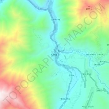
Name: Kargil topographic map, elevation, terrain.
Location: Kargil, Kargil Tehsil, Kargil district, Ladakh, 194103, India (34.51930 76.08558 34.59930 76.16558)
Average elevation: 10,702 ft
Minimum elevation: 8,573 ft
Maximum elevation: 15,902 ft