Geolocate

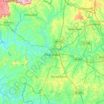
Piracicaba topographic map

Click on the map to display elevation.

Piracicaba

Piracicaba (Portuguese pronunciation: [piɾɐsiˈkabɐ] or [piˌɾasiˈkabɐ]) is a city located in the Brazilian state of São Paulo. The population is 423,323 (2022) in an area of 1,378.07 km2. It is at an elevation of 547 m above sea level.

Wikipedia (CC-BY-SA 3.0)

About this map

Name: Piracicaba topographic map, elevation, terrain.

Location: Piracicaba, Região Imediata de Piracicaba, Região Metropolitana de Piracicaba, Região Geográfica Intermediária de Campinas, São Paulo, Southeast Region, Brazil (-22.90179 -48.09827 -22.52089 -47.49032)

Average elevation: 1,870 ft

Minimum elevation: 1,476 ft

Maximum elevation: 3,484 ft

Gear up for your next adventure:

⌚Solar GPS Watches - Advanced multisport watches with built-in topographic maps
📶Satellite Messenger - Communication device off‑grid
💧Water Purification System - Clean water on the trail with reliable purifiers
🧥Men's Rain Shells - Premium waterproof and breathable jackets for mountain weather
🧤Tactile Hiking Gloves - Keep hands warm while operating GPS and smartphone screens

As an Amazon Associate, this site earns from qualifying purchases at no extra cost to you.