
Make a donation
Gear up for your next adventure:
As an Amazon Associate, this site earns from qualifying purchases at no extra cost to you.
Vermont Heights topographic map
Click on the map to display elevation.
Make a donation
Gear up for your next adventure:
As an Amazon Associate, this site earns from qualifying purchases at no extra cost to you.
Vermont Heights
Vermont Heights is located at 29°48′36″N 81°23′50″W / 29.81°N 81.3972°W / 29.81; -81.3972 (29.81, -81.3972) Elevation of 46 Feet. Vermont Heights is the location of the Coquina Crossing Mobile Home Park and St. Augustine Community School of Performing Arts, both of which give their addresses as being in Elkton to the southwest.
Make a donation
Gear up for your next adventure:
As an Amazon Associate, this site earns from qualifying purchases at no extra cost to you.
About this map
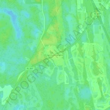
Name: Vermont Heights topographic map, elevation, terrain.
Average elevation: 43 ft
Minimum elevation: 20 ft
Maximum elevation: 59 ft
Saint Johns County trails, hiking, mountain biking, running and outdoor activities
Make a donation
Gear up for your next adventure:
As an Amazon Associate, this site earns from qualifying purchases at no extra cost to you.
Other topographic maps
Click on a map to view its topography, its elevation and its terrain.
Castillo de San Marcos
United States > Florida > Saint Johns County > Saint Augustine
Average elevation: 7 ft
Julington Creek Plantation Park
United States > Florida > Saint Johns County > Fruit Cove
Average elevation: 23 ft
Make a donation
Gear up for your next adventure:
As an Amazon Associate, this site earns from qualifying purchases at no extra cost to you.
Twelve Mile Swamp Conservation Area
United States > Florida > Saint Johns County
Average elevation: 26 ft