Geolocate

Dunbar topographic map

Click on the map to display elevation.

About this map

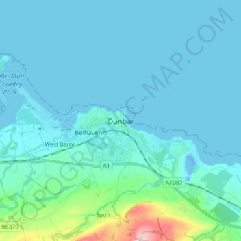
Name: Dunbar topographic map, elevation, terrain.

Location: Dunbar, East Lothian, Scotland, EH42 1ER, United Kingdom (55.96214 -2.55582 56.04214 -2.47582)

Average elevation: 79 ft

Minimum elevation: -43 ft

Maximum elevation: 741 ft

Gear up for your next adventure:

🦶Hiking Gaiters - Keep debris and water out of your boots
📶Satellite Messenger - Communication device off‑grid
🪶Camping Sleeping Pad - Comfortable sleeping pad for backpacking
🎒Gear Packing Cubes - Organize your backpack efficiently
🧭Orienteering Set - Complete compass and map reading kit

As an Amazon Associate, this site earns from qualifying purchases at no extra cost to you.