
Taboada topographic map
Interactive map
Click on the map to display elevation.
About this map
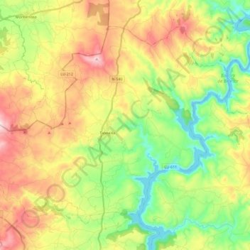
Name: Taboada topographic map, elevation, terrain.
Location: Taboada, Chantada, Lugo, Galicia, España (42.65552 -7.87688 42.78568 -7.65324)
Average elevation: 1,824 ft
Minimum elevation: 1,063 ft
Maximum elevation: 2,927 ft
Other topographic maps
Click on a map to view its topography, its elevation and its terrain.
Penasillás
Penasillás, A Laxe, Chantada, Lugo, Galicia, 27512, España
Average elevation: 2,270 ft
Pesqueiras
Pesqueiras, Chantada, Lugo, Galicia, España
Average elevation: 1,601 ft
Taboada dos Freires
Taboada dos Freires, Taboada, Chantada, Lugo, Galicia, España
Average elevation: 2,057 ft