
Thank you for supporting this site ❤️
Make a donation
Make a donation
Gear up for your next adventure:
As an Amazon Associate, this site earns from qualifying purchases at no extra cost to you.
Limiñón topographic map
Click on the map to display elevation.
Thank you for supporting this site ❤️
Make a donation
Make a donation
Gear up for your next adventure:
As an Amazon Associate, this site earns from qualifying purchases at no extra cost to you.
About this map
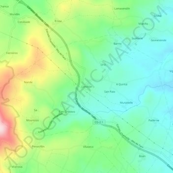
Name: Limiñón topographic map, elevation, terrain.
Location: Limiñón, Muradelle, Chantada, Lugo, Galicia, 27510, España (42.61925 -7.85467 42.65925 -7.81467)
Average elevation: 2,126 ft
Minimum elevation: 1,765 ft
Maximum elevation: 2,887 ft
Thank you for supporting this site ❤️
Make a donation
Make a donation
Gear up for your next adventure:
As an Amazon Associate, this site earns from qualifying purchases at no extra cost to you.
Other topographic maps
Click on a map to view its topography, its elevation and its terrain.