Geolocate
Thank you for supporting this site ❤️Make a donation

Dayton topographic map

Click on the map to display elevation.

About this map

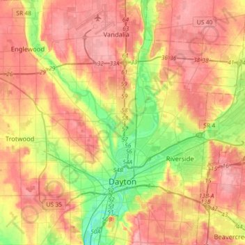
Name: Dayton topographic map, elevation, terrain.

Location: Dayton, Montgomery County, Ohio, United States (39.70185 -84.31138 39.92082 -84.09294)

Average elevation: 886 ft

Minimum elevation: 696 ft

Maximum elevation: 1,040 ft

Dayton's climate features warm, muggy summers and cold, dry winters, and is classified as a humid continental climate (Köppen Dfa). Unless otherwise noted, all normal figures quoted within the text below are from the official climatology station, Dayton International Airport, at an elevation of 1,000 ft (304.8 m) about 10 mi (16 km) to the north of downtown Dayton, which lies within the valley of the Miami River; thus temperatures there are typically cooler than in downtown.

(CC-BY-SA 3.0)

Other topographic maps

Click on a map to view its topography, its elevation and its terrain.

West Carrollton

United States > Ohio > Montgomery County

West Carrollton, Montgomery County, Ohio, 45449, United States

Average elevation: 781 ft

Washington Township

United States > Ohio > Montgomery County

Washington Township, Montgomery County, Ohio, United States

Average elevation: 935 ft

Kettering

United States > Ohio > Montgomery County

Kettering, Montgomery County, Ohio, United States

Average elevation: 902 ft

Miamisburg

United States > Ohio > Montgomery County

Miamisburg, Montgomery County, Ohio, 45342, United States

Average elevation: 810 ft

Residence Park

United States > Ohio > Montgomery County > Dayton

Residence Park, Dayton, Montgomery County, Ohio, 45428, United States

Average elevation: 873 ft

Oakwood

United States > Ohio > Montgomery County

Oakwood, Montgomery County, Ohio, 45419, United States

Average elevation: 919 ft

Dayton

United States > Ohio > Montgomery County

Dayton, Montgomery County, Ohio, 45423, United States

Average elevation: 886 ft

West Side

United States > Ohio > Montgomery County > Dayton

West Side, Dayton, Montgomery County, Ohio, 45407, United States

Average elevation: 761 ft

Trotwood

United States > Ohio > Montgomery County

Trotwood, Montgomery County, Ohio, United States

Average elevation: 902 ft

Riverside

United States > Ohio > Montgomery County

Riverside, Montgomery County, Ohio, United States

Average elevation: 840 ft

Pasadena

United States > Ohio > Montgomery County > Kettering

Pasadena, Kettering, Montgomery County, Ohio, 45429, United States

Average elevation: 981 ft

Greenmont

United States > Ohio > Montgomery County > Kettering

Greenmont, Kettering, Montgomery County, Ohio, 45420, United States

Average elevation: 925 ft

Miami Township

United States > Ohio > Montgomery County

Miami Township, Montgomery County, Ohio, United States

Average elevation: 892 ft

Englewood

United States > Ohio > Montgomery County

Englewood, Montgomery County, Ohio, 45322, United States

Average elevation: 925 ft

Centerville

United States > Ohio > Montgomery County

Centerville, Montgomery County, Ohio, 45459, United States

Average elevation: 945 ft

Miami Shores

United States > Ohio > Montgomery County > Moraine

Miami Shores, Moraine, Montgomery County, Ohio, 45449-0068, United States

Average elevation: 761 ft

In order to remain free and to keep improving, this site uses cookies created by Google to compile visit statistics and display personalized advertisements.

How is the collected data used?